Photo Credits: Dietmar Offenhuber
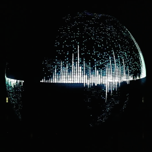
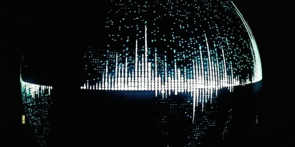
At Miraikan, one of Japan’s most important science centers, a focal-point theme for several years now has been the visualization of global interrelationships. To take this to the next level, the facility developed a jumbo-sized simulator of planet Earth. Geo-Cosmos is a spherical display seven meters in diameter that depicts Earth illuminated in space. Equipped with more than 10 million LEDs, it’s a projection surface suited to the latest satellite images and high-definition visualizations.
Since late November, Geo-Cosmos has displayed an animated film by Dietmar Offenhuber and the Ars Electronica Futurelab. “Sorting Out Cities” is the title of a projection that can depict a wide array of urban data such as the proportion of urbanized areas on the Earth’s surface, the number of this planet’s city dwellers, and the intercity transfer routes of human beings and resources.
We recently had a chance to chat with Dietmar Offenhuber about his passion for cities, the “Sorting Out Cities” project, and his conception of the cities of the future.
 Dietmar, you got your doctorate in urban planning from Massachusetts Institute of Technology and you’ve authored several books on the subject of technology and the city. What’s the source of your great interest in urban life and development?
Dietmar Offenhuber: I think it’s the diversity and complexity with which everyday life is played out in an urban setting, how society manifests itself spatially. Here, I don’t mean city as the opposite of country; nevertheless, density definitely plays a role in the appearance of these spaces.
Your most recent book is entitled “Decoding the City: Urbanism in the Age of Big Data.” Could you give us a brief overview of what it’s about?
Dietmar Offenhuber: The Senseable City Lab investigates how digital communications technologies can help us to better understand cities as well as to improve them. We looked into what role these technologies can play in urban research & development, and which problems have to be addressed in going about this. However, this book isn’t meant solely as a commentary on these phenomena; we also let scientists and developers of new methods of data analysis describe what they’re up to.
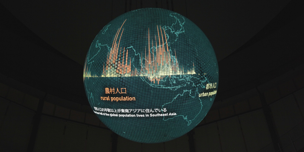
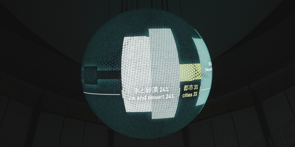 The Geo-Cosmos projection “Sorting Out Cities” is all about data too. What exactly can be seen on the surface of this global simulator?
Dietmar Offenhuber: The point was to bring out the ever-larger role cities are playing globally. When we talk about global development, we usually use abstract magnitudes like Gross National Product that nobody really has a clear conception of. In “Sorting out Cities,” our aim was to translate these abstract magnitudes into concrete spatial dimensions. To accomplish this, we were guided by a simple visual principle: The world is being constantly rearranged in order for those beholding it to more easily conceive the spatial relationships. For example, you can see that cities take up only about 3% of the total land mass, but their inhabitants make up 50% of the population. From these cities, approximately 90% of the Earth’s surface can be reached within two days using conventional means of transportation. It also highlights the incredibly important role that Southeast Asia plays in this global context. The population of this region already exceeds the number of inhabitants of all other regions of the world combined. But in many of these regions, urbanization has only just gotten underway.
 This calls for vast quantities of data. How did you go about generating all of it?
Dietmar Offenhuber: The global data sets were generated by various research projects at universities and by international organizations such as the UN. Here, our top priority was to use only verifiable data from reputable sources.
These data can, of course, also be scientifically evaluated. What exactly can be derived from the visualizations?
Dietmar Offenhuber: The project’s objective isn’t of a scientific nature, but it still demands the use of scientific methods in order to establish interrelationships among these highly diverse data sets. For me, this contextualization is another very important objective in light of the fact that, usually, these data sets are considered in isolation, and then discrete topics—population growth, the economy, CO2 emissions—are considered separately. Naturally, all these things are closely interconnected, but it’s not simple to consider them in the same context.
 How do you imagine the city of the future? In what direction are developments proceeding, and what will change in the future?
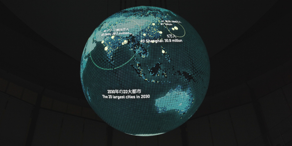
Dietmar Offenhuber: As I see it, a key aspect of the city of the future is informality. Of the world’s 20 largest cities in 2030, only one will be in Europe and two in North America. The rest will be in what used to be referred to as developing countries (though that hasn’t been current for a long time now). However, these megacities are to a great extent characterized by informal economies and infrastructures. Technology plays a role here as well. The smartphone, for example, makes formal processes more informal; as a result, many structures break down. At the same time, it makes informal processes more formal, since, for example, every movement and every conversation via smartphone leaves behind traces. The city of the future will be more chaotic and more dynamic, but most certainly not the way these are portrayed in clinical science fiction and smart city visions.
Dietmar Offenhuber
Dietmar Offenhuber is assistant professor at Northeastern University in Boston and director of its MFA program in Information Design and Visualization. He earned his Ph.D. at the MIT Department of Urban Studies and Planning, and studied at MIT Media Lab’s Sociable Media Group. His fields of research include socio-cultural aspects of urban infrastructure and the role of digital technologies in the political discourse. He has been a research fellow at the MIT Senseable City Lab, key researcher at the Ludwig Boltzmann Institute for Media Art Research, and professor at the Upper Austria University of Applied Sciences in Hagenberg and at Linz Art University.
Dietmar collaborates with sound artists Sam Auinger and Hannes Strobel in a configuration named Stadtmusik. He has exhibited his artistic work at such venues as the Centre Pompidou, the Armory Show in New York, ZKM–Center for Art and Media Karlsruhe, Ars Electronica, the Sundance Film Festival, Secession Vienna, the Seoul International Media Art Biennale and Arte Contemporaneo in Madrid.